About the GreenWay
The Cooks to Cove GreenWay was first conceptualised almost 20 years ago by enthusiastic local community advocates who saw the potential for an environmental, cultural and sustainable transport corridor, including active (non-motorised) transport and public transport (light rail) along the route of the former Dulwich Hill Goods Line.
Vision and significance
An important feature of the Cooks to Cove GreenWay is that the concept has evolved from a grassroots idea that was first conceived around 20 years ago. Several community groups, including environment and cycling groups, have worked hard to build support for the GreenWay, and are still closely involved in its development.
Since its first conception, the idea for the GreenWay has evolved into a clear vision for:
- A recognisable environmental, cultural and nonmotorized transport corridor linking the sub-catchments of two of Sydney’s most important waterways
The Cooks to Cove GreenWay has regional significance as a recreational and active transport route, an ecological corridor and a place of cultural significance.
Stakeholder consultation undertaken during the Masterplan process and subsequent community engagement points, also highlighted the desire for the GreenWay to meet a diverse range of local community aspirations, and for it to retain the local character of places that people know and love.
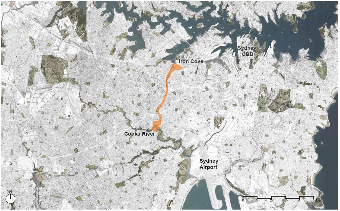
The GreenWay is an environmental and active travel corridor linking the Cooks River at Earlwood with the Parramatta River at Iron Cove.
It mostly follows the route of the Inner West Light Rail and Hawthorne Canal and features bike paths and foreshore walks, cultural and historical sites, cafes, bushcare sites and a range of parks, playgrounds and sporting facilities.
The Greater Sydney Commission has identified the GreenWay as the number one priority "green grid" project in the Eastern Sydney District Plan released in March 2018.
Where is the GreenWay
The Cooks to Cove GreenWay is in Sydney’s Inner West. The Cooks to Cove GreenWay links the Cooks River in Earlwood to the Parramatta River at Iron Cove, and for much of its route, it follows the alignment of the former Long Cove Creek - now Hawthorne Canal. It also follows the route of the light rail (and former Rozelle goods line) corridor via Dulwich Hill, Summer Hill, Lewisham, Haberfield and Lilyfield. It links two well established shared paths – the Bay Run around Iron Cove at its northern end, and the Cooks River shared path at its southern end.
Six GreenWay Precincts
The GreenWay has been divided into six precincts, which are defined by major road crossings:
- Hawthorne Canal Precinct
From Iron Cove to south of Marion Street, including the parklands around Hawthorne Canal including Richard Murden Reserve, Hawthorne Reserve and Blackmore Oval.
- Gadigal Reserve Precinct
From south of Marion Street to south of Longport Street, Including Gadigal Reserve itself as well as the section between Parramatta Road and Marion Street (including the distinctive avenue of figs).
- Mills Precinct
From south of Longport Street to Weston Street, including the area around the Lewisham West light rail station and the stretch along Weston Street.
- Dulwich Hill Parks Precinct
From Weston Street to south of New Canterbury Road, including Hoskins Park and Johnson Park immediately adjacent to the GreenWay corridor, and Arlington and Laxton Reserves nearby. Also including the deeply cut rail corridor between Constitution Road and New Canterbury Road.
- Dulwich Grove Precinct
From south of New Canterbury Road to north of Ewart Street, including the new linear park proposed in the light rail corridor east of Hercules Street and the existing Jack Shanahan Reserve.
- Cooks River Precinct
From north of Ewart Street to the Cooks River, including links on-road, past the golf course and across the Cooks River.
What is a 'greenway'
A 'greenway' is a linear corridor, typically used for recreation and/or active (non-motorised) transport (e.g. walking, running, riding) and sometimes including public transit uses. As the term implies, it is typically a ‘green’ or vegetated corridor.
The term ‘greenway’ is used around the world, and while greenways in different places all have a local flavour, typically:
- They are in urban areas. Being green corridors, they often feature ecological restoration and/or a biodiversity focus, but always feature vegetation
- They follow the routes of other urban infrastructure (such as rail corridors)
- A central feature is an off-road shared path, continuous over several kilometres
Some emphasise recreational use and present an opportunity to escape from urban areas into nature. Others emphasise active transport use and feature strong connections to local destinations
They often invite engagement with local culture, and may feature local history, public art, or other interpretive elements
GreenWay Masterplan
Read the GreenWay Masterplan here
GreenWay community video
The GreenWay video below provides an overview of the GreenWay vision, concepts and activities.