Flooding in the Inner West
Inner West Council is bounded by three primary water bodies – Parramatta River to the north, Cooks River to the South and Sydney Harbour to the east – and contains 5 tributary creek systems – Dobroyd Canal, Hawthorne Canal, Whites Creek, Johnstons Creek and Alexandra Canal. Generally, stormwater north of New Canterbury Road and Enmore Road flows to Parramatta River and Sydney Harbour, while stormwater south of New Canterbury Road and Enmore Road flows to the Cooks River.
Inner West Council can be divided into 9 primary catchments (and suburbs)
| Catchment |
Affected suburbs |
| Dobroyd Canal |
Haberfield, Ashfield |
|
Hawthorne Canal
|
Dulwich Hill, Leichhardt (west of Norton Street), Lewisham, Petersham (north of New Canterbury Road), Summer Hill
|
| Whites Creek |
Annandale (west of Johnston Street), Leichhardt (east of Norton Street), Lilyfield, Stanmore (west of Percival Road) |
|
Johnstons Creek
(shared with City of Sydney)
|
Annandale (east of Johnston Street), Camperdown, Enmore (north of Enmore Road), Newtown (north of Enmore Road), Stanmore (east of Percival Road) |
| Marrickville Valley |
Marrickville, Sydenham |
| Marrickville South |
|
| Eastern Channel East |
Enmore (south of Enmore Road), Newtown (south of Enmore Road), St Peters |
| Alexandra Canal |
St Peters (south of Princes Highway), Tempe |
|
Foreshore
(a combination smaller catchments draining directly to Parramatta River or Sydney Harbour)
|
Balmain, Birchgrove, Lilyfield, Rozelle |
There are also two smaller areas that contribute to flood management within Burwood Council and City of Canada Bay Council.
Categorising flood events
Flooding within Inner West Council can generally be described as flash flooding – flooding which is sudden and unexpected (typically within 6 hours of the contributory rain) – often caused by sudden local or nearby heavy rainfall. This is generally attributable to the age of the existing stormwater system, the nature of the topography of the LGA, the heavily urbanised nature of the LGA and the associated history of development, as well as the impact of the major waterways within the LGA.
Flooding in Inner West Council can be categorised in three ways:
- Overland flooding, where water flows along and through natural valleys and constructed drainage channels through streets and properties on its way to the river, creek or harbour
- Riverine flooding, also called mainstream flooding, where the banks of the creek or river are exceeded inundating adjacent low lying areas
- Coastal impacts, largely confined to areas of the Parramatta River and Sydney Harbour foreshore, where tidal forces and wave action may over top the foreshore level and run‑up the seaward land area
Some properties within Inner West Council may experience a combination of the above flood impacts.
What actions Council has undertaken to date ?
Floodplain management is coordinated by Council’s Infrastructure Planning team within the Footpaths, Roads, Traffic and Stormwater Group. Inner West Council, and its predecessors, has been undertaking food risk studies across the 9 primary catchments within its LGA since 2009 in accordance with the NSW Flood Prone Land Policy. The policy specifies a staged approach to the floodplain management process, as identified in Figure 1 below.
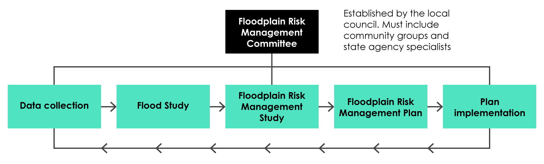
Figure 1: Summary of the floodplain risk management process
To date Council has completed Overland Flood Studies for 8 of its 9 catchments, a tide and storm levels study along the Parramatta River and Sydney Harbour foreshore, as well as contributing to the Cooks River Flood Study and the Parramatta River Estuary Coastal Zone Management Study and Plan.
Council has also completed flood risk management studies and plans for all areas within the former Leichhardt LGA, Marrickville Valley and Eastern Channel East. Council is currently finalising its Flood Risk Management Study and Plan for the Hawthorne Canal and Dobroyd Canal. These plans assess existing and potential flood management issues within the associated catchment and potential management and mitigation measures.
Links to further information and other key agencies
Links to flood studies and flood risk management studies and plans
Current studies on exhibition
If you would like to see current studies please visit our Your Say Inner West website
How to get a flood certificate
A flood certificate provides details of the flood characteristics in the vicinity of a property, including:
- The extent of flooding around a property
- The flood hazard
- Flood levels for the 1% AEP flood event and the PMF event
- Depth of flooding for the 1% AEP event
These details can inform property owners of flood risk and provide guidance for future development in accordance with Council's development controls.
The information provided is extracted from Council’s adopted Flood Studies and is provided is provided in good faith and in accordance with the provisions of s.733 of the Local Government Act.
For more information on this permit and to be taken through the application process, please use the link below:
Flood certificate
Stormwater
Property owners are responsible for stormwater outlets from their property to the kerb and gutter. Please contact council if you believe your stormwater outlet has been impacted by works.
Stormwater may present issues for residents, especially if it is coming from a neighbouring property. The flow of water in these instances may lead to disputes, and Council does its best to ensure that proper action is taken if required and/or possible. If you want to know more about how council deals with Stormwater or check to see if Council may investigate issues relating to the overland flow of water from one property to another property - please check the below page for more information:
Stormwater