Introduction
The Inner West is located in one of Australia's most species diverse bioregions and has a variety of native plants that can be used at home, in the neighbourhood, and for regenerating public land and waterways.
Prior to colonisation, the Inner West was an Aboriginal managed landscape that contained wet and dry eucalypt forests, saltmarshes and mangrove swamps, and freshwater lagoons and forested wetlands. These 'native plant communities' were extensively cleared for development, and some are now threatened with extinction.
Council is working with residents and volunteers to restore or recreate our native plant communities on public and private land. Our native plants are well adapted to the local environment, and they can be used to create beautiful and unique landscapes for people and wildlife to enjoy.
Read below to learn about our native plant communities, and use the resources provided to select Inner West plant species that will provide colour, screening, and habitat for your balconies, backyards, and verge gardens.
Useful Resources
Trees Near Me NSW - use the interactive map to explore the native plant communities around you
Which Plant Where - a free tool for selecting resilient and ecologically beneficial plants for your garden
Inner West Native Plant List - a list of local tree, shrub and groundcover species that are suitable for your garden and generally available for sale at Council's Community Nurseries
Native Plant Communities of the Inner West
The Inner West has six native plant communities, or plant community types (PCTs), as defined by the NSW government and provided as an interactive map on Trees Near Me. The plant communities have distinct combinations of tree, shrub, and/or groundcover species that frequently occur together. Although the Inner West has been extensively cleared, some remnant patches can still be found, and there are many other sites where our native plant communities are being restored or recreated.
Sydney Turpentine-Ironbark Forest (STIF) is a type of Wet Sclerophyll Forest that once covered a large part of the Inner West from Newtown to Ashfield, and Lilyfield to Marrickville. STIF typically contains a grassy groundcover layer and was managed by the Gadigal and Wangal as a kangaroo hunting ground in the eastern suburbs of the Inner West. STIF was heavily cleared for timber and agriculture, and is now a Critically Endangered Ecological Community, with less than 0.5% of its original extent intact.
Some small, modified remnant patches of STIF remain in the Inner West and Council's Urban Ecology team is working with volunteers to re-create or restore this plant community.
Where can you find STIF?
- Camperdown Cemetery - remnant grass and groundcover layer
- Victoria Square, Summer Hill - remnant grass and groundcover layer
- Davis Street, Dulwich Hill - re-vegetated tree and shrub layers next to Waratah Mills Light Rail Station

Sydney Coastal Sandstone Foreshores Forest (SCSFF) is a Dry Sclerophyll Forest that hugged the sandstone hills and cliffs around the coastline. It wrapped around the Balmain Peninsula from Haberfield to Rozelle and overlooked the Cooks River from Dulwich Hill to Tempe. The tree canopy is frequently dominated by the iconic Sydney Red Gum (Angophora costata), with an understorey of Coast Banksia (Bankisa integrifolia) and 'mesic' species such as the Cheese Tree (Glochidion ferfinandi) and Blueberry Ash (Elaeocarpus reticulatus).
Where can you find SCSFF?
- Marrickville Golf Course - especially Bushcare sites next to the clubhouse and along Beauchamp Street
- Richardson's Lookout and Warren Park
- Leichhardt Park - north of the Aquatic Centre and Leichhardt Oval #2
NB: Sydney Coastal Enriched Foreshore Forest is a related plant community that is mapped as historically occurring in Balmain East around Datchett Street and Johnston Street Reserves.
Estuarine Swamp Oak Twig-rush Forest (ESOTF) is a forested wetland that occurred on the river floodplains between the mangroves and sclerophyll forests. It was once found in patches on the Parramatta River at Easton Park and Rozelle Parkland, and it extended southwards from Marrickville Golf Course in the Cooks River Corridor. The tree canopy in ESOTF was dominated by Swamp Oak (Casuarina glauca), which were known as 'babysitter trees' to Sydney's Aboriginal people, and also provided raw material for canoes and weapons.
Casuarina species are still commonly found planted in public parks and reserves. However, ESOTF was extensively cleared and drained in the Inner West, and is listed as part of an endangered ecological community called the Swamp Oak Floodplain Forests of New South Wales North Coast, Sydney Basin and South-east Corner Bioregions.
Where can you find ESOFT?
Modified and/or re-created stands of Swamp Oak Forest can be found at:
- Tempe Lands - Natural Area with wetland and walking tracks
- Steel Park - with the saltmarsh behind the waterplay park
Estuarine Reedland is a type of freshwater wetland commonly found in coastal estuaries. It typically occurs on the landward side of saltmarsh flats, where fresh and salty water can flow or seep into low-lying depressions. In the Inner West, it was once found along the line of Alexandra Canal, from Tempe Reserve up to Campbell Road at Sydney Park.
Freshwater wetlands often provide crucial habitat (especially for migratory species), and the re-created reedlands at Tempe Lands is one of the most diverse and abundant sites for bats and birds in the Inner West. Estuarine Reedland is part of an endangered ecological community called the Swamp Oak Floodplain Forests of New South Wales North Coast, Sydney Basin and South-east Corner Bioregions.
Where can you find Estuarine Reedland?
Degraded, modified and/or re-created reedland can be found at:
- Tempe Lands - re-constructed wetland and walking tracks
- Alexandra Canal - behind the Airport Viewing Area
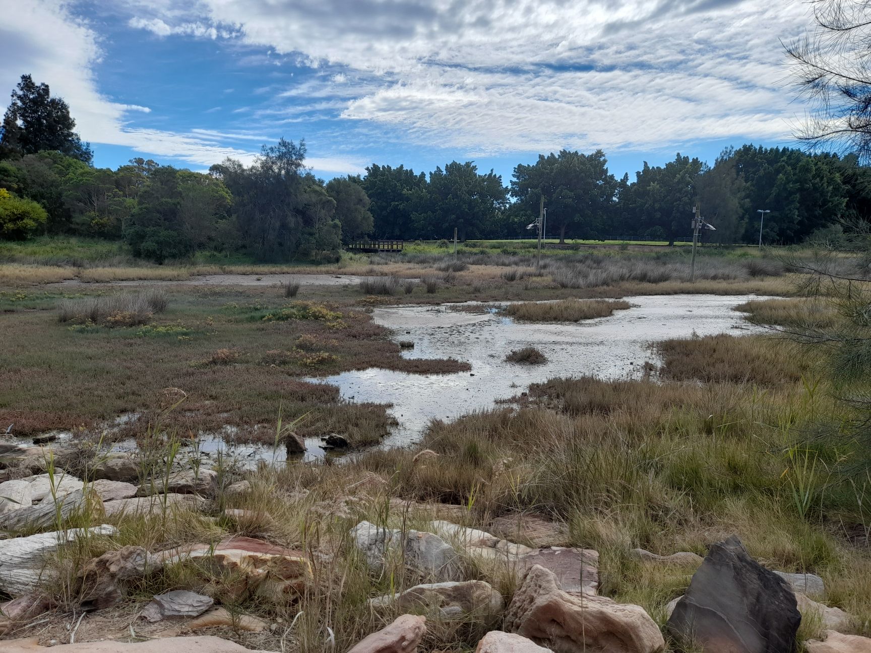
Samphire Saltmarsh is a saline wetland that typically occurs in estuarine, coastal mudflats where tidal inundation creates an extremely salty and hostile environment for ordinary plants. In the Inner West, it most likely occurred on the landward side of mangrove forests, and an extensive saltmarsh was recorded at Rozelle Bay where Whites Creek and Johnston Creek empty into Parramatta River. Saltmarsh is a highly productive ecosystem and an important nursery for many aquatic species. It was an important source of shellfish, waterbirds, and raw materials for Aboriginal people.
Saltmarsh was extensively drained and/or filled for development, with little to no remnant saltmarsh remaining in the Inner West. Samphire Saltmarsh is part of an endangered ecological community called the Coastal Saltmarsh of New South Wale North Coast, Sydney Basin, and South-east Corner Bioregions.
Where can you find Samphire Saltmarsh?
Re-created saltmarsh can be found at:
- Steel Park - along the Cooks River at the Waterplay park
- Tempe Recreation Reserve - next to the netball courts alongside Alexandra Canal
- Richard Murden Reserve - along Hawthorne Canal near the netball courts (southern end)
Grey Mangrove-River Mangrove Forest (GMRMF) is a saline wetland that was found along the Cooks River and fringing the coastal coves in Haberfield, Rozelle, and White Bay. Mangrove forests are critical habitat for a wide variety of species and provide essential 'ecosystem services' such as reducing erosion, removing nutrients and trapping pollutants, and protecting coastal infrastructure from severe storm damage.
Where can you find GMRMF?
- Cooks River foreshore
- Parramatta River near Haberfield Rowers Club

Volunteers restoring remnant Sydney Turpentine-Ironbark Forest grassland at Camperdown Cemetery, Newtown.

Re-created saltmarsh, inundated with open water, at Tempe Reserve, Tempe

A re-created stand of Sydney Coastal Sandstone Foreshores Forest at Mort Bay, Birchgrove

Re-created freshwater wetland at Tempe Lands, Tempe

Casuarina and Mangroves meet at the river's edge - Kendrick Park, Tempe